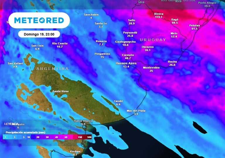
At Bourke, Louth, Tilpa, Wilcannia, Menindee, Pooncarie and Burtundy
Flood Warning
2022-07-01 14:42
2022-07-04 14:42
Comentario
Minor to Major Flood Warning for the Darling River
Detalle
*Re-issued to correct river level observation at Bourke*MAJOR FLOODING POSSIBLE AT TILPA LATE NEXT WEEKMODERATE FLOODING OCCURRING AT LOUTH AND TILPA, LIKELY AT WILCANNIAMINOR FLOODING OCCURRING AT BOURKE, WILCANNIA, MENINDEE AND BURTUNDYMINOR FLOODING LIKELY AT POONCARIE FROM AROUND MONDAYThe main flood peak along the Darling River has now passed Bourke, where minor flooding is easing slowly. This flood peak is now at Louth, where moderate flooding continues.Downstream at Tilpa, moderate flooding continues and further rises to the major flood level are possible late next week.At Wilcannia, moderate flooding is likely over the weekend and is expected to continue through to late July.At Menindee, river levels are likely to remain near 9.00 metres through to July as WaterNSW plans to maintain current release levels. The release plan follows consultation with the SES and local communities.Minor flooding is occurring at Burtundy and is likely at Pooncarie over the weekend.
At Menangle, Camden, Wallacia, Penrith, North Richmond, Windsor, Sackville, Lower Portland, Wisemans Ferry and Putty Road
Flood Warning
2022-07-04 01:41
2022-07-06 01:41
Comentario
Moderate to Major Flood Warning for the Nepean, Hawkesbury and Colo Rivers
Detalle
MAJOR FLOODING OCCURRING AT NORTH RICHMOND WITH RIVER LEVELS EXCEEDING MARCH 2022 EVENT. FURTHER RISES TO LEVELS AROUND MARCH 2021 EVENT POSSIBLE MONDAY MORNINGMAJOR FLOODING OCCURRING AT MENANGLE WHERE RIVER LEVELS PEAKED SLIGHTLY LOWER THAN THE APRIL 2022 FLOODHeavy rainfall over the Nepean Valley since Saturday morning coupled with high dam levels have resulted in major flooding in the Nepean River at Menangle where river levels have exceeded the flood height reached in the March 2022 flood event (15.92 metres) and peaked slightly below the April 2022 flood height (16.83 metres).Further downstream, spills from Warragamba Dam combined with inflows from the Upper Nepean River have caused major flooding at North Richmond where further river level rises are expected during Monday. River levels have exceeded the flood height reached in the March 2022 flood event (14.09 metres). Further heavy rainfall is forecast which may result in river level rises to around the March 2021 flood height at North Richmond (14.38 metres) Monday morning.Flood levels at Windsor are likely to reach around the flood levels reached in the March 2021 and March 2022 flood events.Flood levels at Sackville and downstream are likely to be lower than the March 2022 levels.A Severe Weather Warning for heavy rainfall is current for the Metropolitan, Illawarra, parts of Hunter and Central Tablelands Forecast Districts.
At Bathurst
Flood Warning
2022-07-04 04:16
2022-07-07 04:16
Comentario
Moderate Flood Warning for the Macquarie River
Detalle
MODERATE FLOODING OCCURRING AT BATHURSTModerate to heavy rainfall recorded across the upper Macquarie River catchment since Saturday has caused river level rises. Moderate flooding is occurring along the Macquarie River at Bathurst.Further rainfall is forecast over the next 12 to 24 hours which may cause renewed river level rises. This situation is being closely monitored and revised predictions will be provided as necessary.
At Bulga and Maitland
Flood Warning
2022-07-04 02:18
2022-07-06 02:18
Comentario
Minor to Moderate Flood Warning for Wollombi Brook and the Lower Hunter River
Detalle
MODERATE FLOODING POSSIBLE AT BULGA LATE MONDAYMINOR FLOODING POSSIBLE AT MAITLAND FROM LATE MONDAY MORNINGHeavy rainfall over the past 24 hours has caused river level rises across the Hunter River catchment.Moderate flooding is possible at Bulga from Monday evening, and minor flooding is possible at Maitland from late Monday morning.Further rainfall is forecast during Monday into Tuesday, which may cause further river level rises. This situation is being closely monitored, and revised predictions will be provided as necessary.A Severe Weather Warning for heavy rainfall is current for the Metropolitan, Illawarra, and parts of the Hunter and Central Tablelands Forecast Districts.
At Weilmoringle, Kenebree and Goodwins
Flood Warning
2022-07-01 14:40
2022-07-04 17:40
Comentario
Minor to Moderate Flood Warning for the Culgoa and Bokhara Rivers
Detalle
"Re-issued to correct the peak level observation at Kenebree"MODERATE FLOODING OCCURRING AT KENEBREE AND GOODWINSMINOR FLOODING OCCURRING AT WEILMORINGLEAlong the Culgoa River, minor flooding continues at Weilmoringle where river levels are easing slowly. The main flood peak has passed through Kenebree, where moderate flooding continues.Along the Bokhara River, moderate flooding continues at Goodwins where river level peaked during Wednesday, with moderate flooding.
At Wellington, Dubbo, Narromine, and Warren
Flood Warning
2022-07-04 00:45
2022-07-07 00:45
Comentario
Minor to Moderate Flood Warning for the Macquarie and Bell Rivers
Detalle
MODERATE FLOODING OCCURRING ALONG THE BELL RIVER AT WELLINGTONMODERATE FLOODING POSSIBLE AT WARRENMINOR FLOODING OCCURRING ALONG THE MACQUARIE RIVER AT WELLINGTONMINOR FLOODING LIKELY AT DUBBO AND NARROMINE FROM MONDAYModerate to heavy rainfall since Friday has caused minor to moderate flooding across the Bell and Macquarie River catchments.Moderate flooding is occurring along the Bell River at Wellington, where river levels are nearing a peak. Moderate flooding is possible along the Macquarie River at Warren Monday evening.Minor flooding is occurring along the Macquarie River at Wellington, and minor flooding is likely at Dubbo, Narromine, and Warren during Monday.Further rainfall is forecast over the next 24 hours. This situation is being closely monitored and revised predictions will be provided as necessary.
At Nowra and Terara
Flood Warning
2022-07-04 03:53
2022-07-05 03:53
Comentario
Minor Flood Warning for the Shoalhaven River
Detalle
RENEWED MINOR FLOODING LIKELY AT NOWRA AND TERARA FROM LATE MONDAY MORNINGModerate to heavy rainfall since Friday has caused minor flooding along the Shoalhaven River, where river levels peaked during Sunday.Renewed rises and minor flooding are likely from Monday morning along the Shoalhaven River at Nowra and Terara.Further rainfall is forecast during Monday into Tuesday, which may cause further river level rises and prolonged flooding. This situation is being closely monitored, and revised predictions will be provided as necessary.A Severe Weather Warning for heavy rainfall is current for the Metropolitan, Illawarra, and parts of the Hunter and Central Tablelands Forecast Districts.
At Booligal
Flood Warning
2022-07-01 10:31
2022-07-04 10:31
Comentario
Minor Flood Warning for the Lachlan River
Detalle
MINOR FLOODING OCCURRING AT BOOLIGALMinor flooding continues along the Lachlan River at Booligal, where river levels are rising.The Lower Lachlan River at Hillston Weir peaked below minor during Wednesday (29 June) and this flood peak is approaching Whealbah. This peak has the potential to cause renewed rises at Booligal around mid July.
At Gostwyck
Flood Warning
2022-07-04 00:02
2022-07-05 00:02
Comentario
Initial Minor Flood Warning for the Paterson River
Detalle
MINOR FLOODING POSSIBLE AT GOSTWYCK MONDAY MORNINGModerate to heavy rainfall over the past 24 hours has caused river level rises along the Paterson River and its upper tributaries.Minor flooding is possible at Gostwyck from Monday morning.Further rainfall is forecast into Monday and Tuesday, which may cause further river level rises. This situation is being closely monitored, and revised predictions will be provided as necessary.A Severe Weather Warning for heavy rainfall is current for the Metropolitan, Illawarra, and parts of the Hunter and Central Tablelands Forecast Districts.
At Peak Hill and Dandaloo
Flood Warning
2022-07-03 22:09
2022-07-07 01:09
Comentario
Initial Minor Flood Warning for the Bogan River
Detalle
MINOR FLOODING LIKELY AT PEAK HILL SUNDAY EVENING AND AT DANDALOO EARLY NEXT WEEKModerate rainfall recorded across the Bogan River catchment since Saturday morning has cause river level rises at Peak Hill.Minor flooding is likely at PeaK Hill Sunday evening and at Dandaloo early next week.
Metropolitan, Illawarra and parts of Hunter and Central Tablelands Forecast Districts.
Severe Weather Warning
2022-07-03 22:57
2022-07-04 05:00
Comentario
Heavy rainfall and locally damaging winds likely about central NSW on and east of the ranges.
Detalle
Although rain rates have generally eased, HEAVY RAINFALL which may lead to FLASH FLOODING is forecast to continue in the Illawarra, Blue Mountains, Sydney Metropolitan, and parts of Hunter (including Central Coast) districts late evening and overnight.Heavy rainfall is expected to continue over the Sydney Metropolitan and Illawarra districts Monday morning before starting to ease during the afternoon.Six-hourly rainfall totals between 60 to 100 mm are possible.DAMAGING WINDS averaging 65 km/h with peak gusts in excess of 90 km/h are likely along the coastal fringe, during Sunday late evening, easing during the overnight period.Heavy rainfall will further contribute to flooding already being experienced, and increases the potential for landslides. The damaging winds may lead to debris on roads and provides the risk for trees toppling in softer soils.Various flood warnings and watches are current, including some MODERATE to MAJOR flooding in some high population areas, so please refer to those flood warnings at http://www.bom.gov.au/nsw/warnings/ and heed the advice of authorities.A Severe Weather Warning for Damaging Surf is also current along parts of the central coastline.Locations which may be affected include Newcastle, Gosford, Cessnock, Maitland, Sydney, Penrith, Parramatta, Wollongong, Nowra, Bowral, Campbelltown, Katoomba and Lithgow.Severe weather is no longer occurring in the Mid North Coast district and the warning for this district is CANCELLED.Rainfall from 9am Sunday to 4pm Sunday:Maitland Airport 104mmMaitland (Belmore Br) 101mmCrawford 96mmRainfall from 9am Saturday to 9am Sunday:Brogers Creek 368mmWattamolla 318mmDarkes Forest 298mmWoronora Dam 270mmFitzroy Falls Dam 265mmRobertson 258mmA building at Corrimal sustained roof damage and partial collapse Saturday evening.
At Island Point Road and Sussex Inlet
Flood Warning
2022-07-04 03:40
2022-07-07 03:40
Comentario
Minor Flood Warning for the St Georges Basin
Detalle
MINOR FLOODING LIKELY AT ISLAND POINT ROAD AND SUSSEX INLET DURING MONDAYHeavy rainfall since Friday afternoon has caused river levels rises across the St Georges Basin.Minor flooding is likely at Island Point Road from Monday afternoon. Minor flooding is likely at Sussex Inlet on the high tides during late Monday morning and late Monday night.Further rainfall is forecast during Monday into Tuesday, which may cause further river level rises and prolonged flooding. This situation is being closely monitored, and revised predictions will be provided as necessary.A Severe Weather Warning for heavy rainfall is current for the Metropolitan, Illawarra, and parts of the Hunter and Central Tablelands Forecast Districts.
At Tempe
Flood Warning
2022-07-03 13:41
2022-07-04 13:41
Comentario
Minor Flood Warning for the Cooks River
Detalle
MINOR FLOODING POSSIBLE AT TEMPE SUNDAY EVENING ON THE HIGH TIDEHeavy rainfall recorded across the Cooks River catchment since Saturday morning combined with high tide may cause minor flooding at Tempe Bridge on Sunday night.A Severe Weather Warning for heavy rainfall is current for the Metropolitan, Illawarra and parts of Hunter and Central Tablelands Forecast Districts.A Flood Watch is current for the Lower Hunter and Central Coast. This notes the potential for renewed and higher flooding along rivers where flood warning are current.
At Liverpool, Milperra, Picnic Point and Woronora
Flood Warning
2022-07-03 22:53
2022-07-04 22:53
Comentario
Minor Flood Warning for the Georges and Woronora Rivers
Detalle
MINOR FLOODING OCCURRING AT LIVERPOOL AND MILPERRARENEWED MINOR FLOODING POSSIBLE AT PICNIC POINT AND WORONORA ON THE HIGH TIDEHeavy rainfall since Saturday has caused river level rises across the Georges and Woronora River catchments. Flooding is easing along the Georges River at Liverpool and Milperra, where minor flooding continues. Renewed minor flooding is possible at Picnic Point and Woronora overnight Sunday into Monday on the high tide.Heavy rainfall is forecast for the remainder of Sunday into Monday, which may cause renewed river level rises. This situation is being closely monitored and revised predictions will be provided as necessary.A Severe Weather Warning for heavy rainfall is current for the Metropolitan, Illawarra, parts of Hunter and Central Tablelands, and parts of the Mid North Coast Forecast Districts.
At Long Jetty
Flood Warning
2022-07-04 04:23
2022-07-05 04:23
Comentario
Initial Minor Flood Warning for Tuggerah Lake
Detalle
MINOR FLOODING LIKELY AT LONG JETTY MONDAY AFTERNOONModerate to heavy rainfall since Saturday has caused river level rises across the Tuggerah Lake catchment.Minor flooding is likely at Long Jetty from Monday afternoon.Further rainfall is forecast during Monday into Tuesday, which may cause further river level rises and prolonged flooding. This situation is being closely monitored, and revised predictions will be provided as necessary.A Severe Weather Warning for heavy rainfall is current for the Metropolitan, Illawarra, and parts of the Hunter and Central Tablelands Forecast Districts.
Parts of Hunter, Metropolitan and Illawarra Forecast Districts.
Severe Weather Warning
2022-07-04 03:52
2022-07-04 09:00
Comentario
Very heavy surf persisting during today.
Detalle
VERY HEAVY SURF which may lead to localised damage and coastal erosion is expected to continue during today before starting to ease during the afternoon.Areas impacted may include exposed coasts of the Hunter, Metropolitan and Illawarra Forecast Districts.Significant wave heights of over 5m are likely with peak periods around 11 seconds.Wave directions will be from the East and South East.Beach conditions in these areas could be dangerous and people should stay well away from the surf and surf exposed areas.Warnings for other phenomena are also current for these areas.Locations which may be affected include Newcastle, Gosford, Sydney, Wollongong, Albion Park and Kiama.Wave heights of 5m and above have been recorded at the Sydney wave buoy during this morning and Sunday evening.